Rare Element Resources
Bear Lodge Project
Canadian NI 43-101 Technical Report
October 9
th
, 2014
10135-200-46 - Rev. 0
14-2
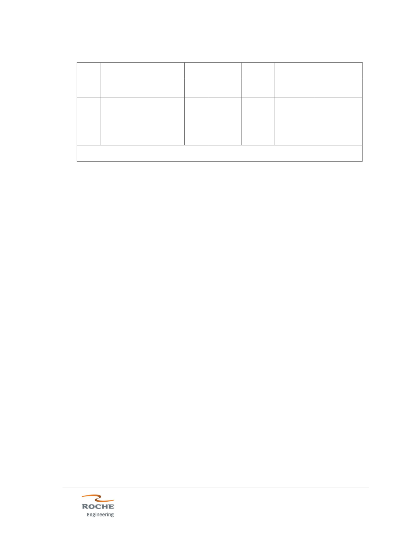
Table 14.1 - Block Model Size and Location Parameters
Axis
Origin
(UTM ft.)
Maximum
(UTM ft.)
Block Size
Number
of
Blocks
Model Size
(feet)
(meters)
approx.
(feet)
(meters)
approx.
X
1,781,500
1,786,900
10
3.05
540
5,400
1,646
Y
16,160,700 16,166,000
10
3.05
530
5,300
1,615
Z
5,000
6,520
10
3.05
152
1,520
462
Coordinates are UTM Zone 13, NAD 83, NAVD 88, US survey feet
(A. Nobel 2014)
14.3 Resource Estimation Geometric Controls
Bounding solids were defined for nine estimation domains, as listed in Table 14.2.
The domain boundaries were constructed from cross-sectional-view strings defined to
enclose areas with consistent overall grades and grade zoning. Cross-sections were
spaced at 50-to-100-ft intervals and were aligned roughly perpendicular to the overall
trend of mineralization in each domain. (Note: Domain boundaries for Northwest Bull
Hill and the Whitetail 2 domains were drawn in plan view.) Since the boundaries
between domains are generally indistinct and/or gradational, the domain boundaries
are drawn with a slight overlap. The domain boundaries were linked to form
wireframed solids, and the solids were filled with 10x10x10-foot blocks to create the
domain block model.
The overlapping boundaries were resolved for the block model by overprinting the
individual models with the Studio 3 ADDMOD process in the order of the priorities
listed in Table 14.2. Thus, W2 is overprinted onto NW; WT1 is overprinted onto the
NW+W2 result; and so on.
Composites were selected within the entire volume of each domain for resource
estimation. Thus, the domain boundaries were treated as semi-soft boundaries for
composite selection. The use of semi-soft boundaries for composite selection is
justified by the indistinct/gradational nature of the domain boundaries.
14.4 Trend Surfaces
Good continuity is generally indicated for the REE-bearing veins, but continuity is not
planar in either the vertical or horizontal view. Accordingly, trend surfaces were
created to define the continuity of mineralization within each resource domain. The
trend surfaces were defined using the same cross-sectional alignment as was used


