Rare Element Resources Ltd. (TSX V: RES and AMEX: REE) ("Rare Element" or the "Company") is pleased to report an NI 43-101-compliant inferred mineral resource estimate for the 100% owned Sundance gold project in the Bear Lodge Mountains, Crook County, northeastern Wyoming.
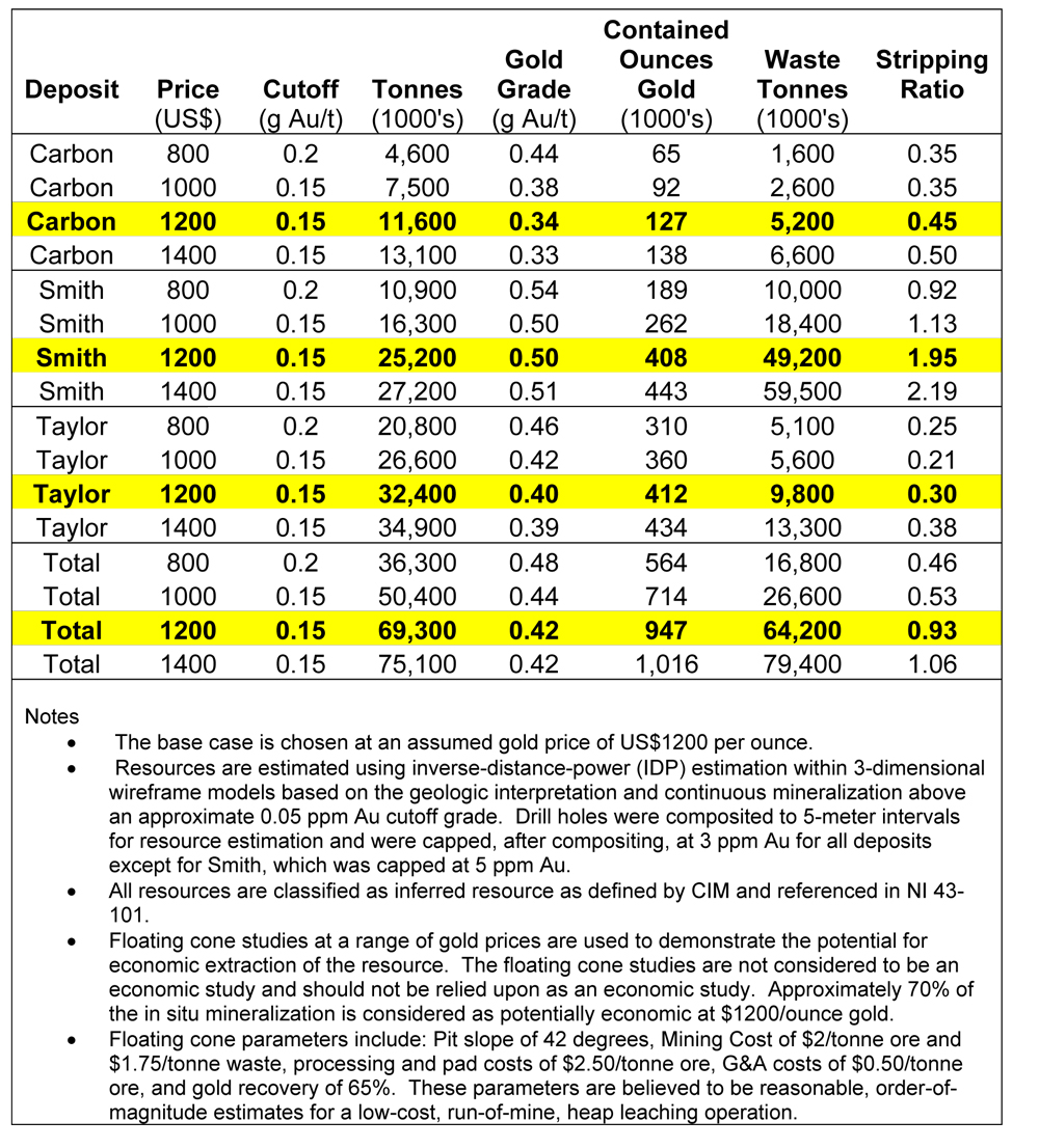
- 947,000 ounces of gold in three deposits contained in 69.3 million metric tonnes averaging 0.42 g Au/t using a 0.15 g/t cutoff grade
Rare Element Resources Ltd. (TSX V: RES and AMEX: REE) ("Rare Element" or the "Company") is pleased to report an NI 43-101-compliant inferred mineral resource estimate for the 100% owned Sundance gold project in the Bear Lodge Mountains, Crook County, northeastern Wyoming. The gold resource estimate was prepared by Ore Reserves Engineering (O.R.E.) of Lakewood, Colorado. The Company continues to advance the geological understanding of the Sundance gold project by defining an inferred mineral resource and by metallurgical testing to determine the recoverability of gold within that resource.
Rare Element's plans for 2011 include completion of metallurgical tests of the Smith deposit mineralized rock, continuation of geochemical and structural reviews, conducting a limited geophysical survey (CSAMT), and rotary and core drilling to define the lateral limits of known gold resources at Smith, Taylor, and Carbon, which are open in several directions, as well as deeper and outlying targets.
Drill-hole Database Compilation and Resource Estimation
Following compilation of the Sundance drill-hole database, O.R.E. analyzed the data to determine the size, shape, and internal continuity of the three principal gold deposits in order to calculate inferred resources. Alan C. Noble, P.E., is the Principal Engineer of O.R.E. and is an independent Qualified Person for the purpose of Canadian NI 43-101, Standards of Disclosure for Mineral Projects. These wireframe models will also be utilized to design the optimal placement of new drill holes to be completed in 2011.
The East and West Breccias of the Smith deposit were discovered by FMC (1982-1986), and subsequently explored by International Curator and Coca Mines. In 1991, Coca estimated a historical resource of 8.2 million tons (7.4 million metric tonnes) at a grade of 0.02 ounces of gold per ton (0.68 g/t) (not NI 43-101compliant) for the two deposits. The new O.R.E. resource estimate updates this historical resource to the current standards and incorporates the drilling done during the past several years by Rare Element and Newmont Mining Company. The new Smith resource includes 25.2 million tonnes grading 0.50 ounces of gold/tonne at a cutoff of 0.15 opt (Table 1). Resource estimates for the Taylor and Carbon areas are also shown in Table 1.
* The Company is not treating the historical estimate as NI 43-101 defined resources verified by a qualified person, and the historical estimate should not be relied upon.
Table 1: Inferred gold resources estimated by O.R.E. for the Sundance project
"The Sundance gold project is progressing well and the new resources estimate will be used to guide a subsequent planned drilling program. Our 2011 exploration program will focus on expanding zones of greater than 1 g Au/t mineralization to enhance future economic evaluations. This resource is provided for information and the Company believes that subsequent work on the gold targets may provide an asset that has the potential to substantially increase in size and value to the Company in the future." stated Don Ranta, President of Rare Element.
Drill-hole Results from the 2010 Program
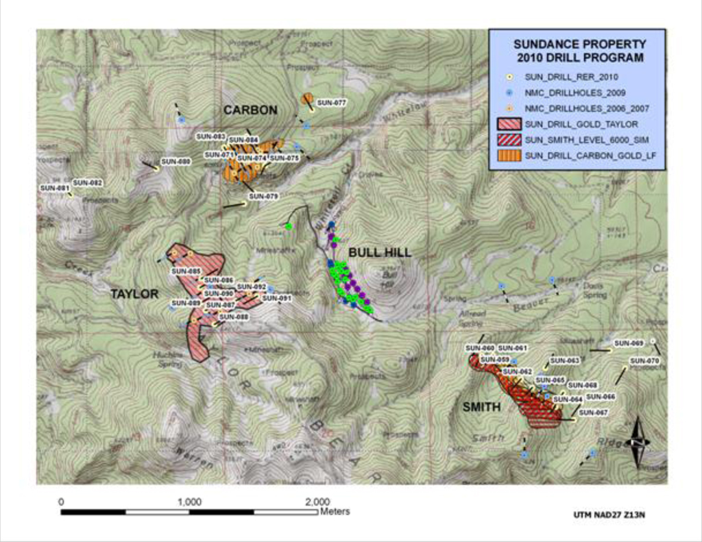
The Company announced assay results from the 2010 rotary (reverse circulation) drill program in three previous press releases (dated September 21 and November 15, 2010 and January 3, 2011). Thirty-four rotary drill holes containing 21,605 feet (6,585 m) were drilled during 2010 on near-surface targets within oxide zone mineralization at the Smith, Carbon, and Taylor target areas (Figure 1). Significant intercepts from the 2010 program are listed in Table 2. Gold exploration activity during 2010 focused on: 1) detailed definition of known gold-mineralized targets with in-fill drilling, 2) step-off drilling from known mineralization, and 3) discovery of gold mineralization in new peripheral gold targets.
Figure 1: Plan map showing the location of the Smith, Carbon, and Taylor gold target areas within part of Rare Element Resources' Sundance Property. The gold targets surround the Bull Hill REE deposit. The drill hole collars from the 2010 program are shown in yellow. Drill-indicated gold-mineralized areas that contain greater than 300 ppb (>0.3 g/t) gold for each target area are shown as ruled polygons.
Smith Gold Target
Highlights of the drilling program at Smith include the following gold assay results:
-
SUN 60 85.4 m @ 0.89 g/t, including 44.2 m @ 1.3 g /t
-
SUN 62 143.3 m @ 0.74 g/t, including 15.2 m @ 1.6 g/t
-
SUN 64 77.7 m @ 0.66 g/t, including 7.6 m @ 1.7 g/t
Eight holes were drilled along the main trend of the Smith gold zone (Figure 2). The primary host rock is heterolithic breccia that is now traced along strike for nearly 1000 meters and down dip for 500m. In drill hole SUN-060, gold mineralization was penetrated along strike to the northwest in peripheral wall rock, which is now recognized as a new host rock for gold mineralization at this target. SUN-062 effectively bridges a gap between the historic "Smith East and Smith West" gold-mineralized breccias, where a historical resource (non NI 43-101 compliant) was defined previously by FMC Gold, International Curator, and Coca Mines. SUN-064 tests a nearer surface zone along strike to the southeast. SUN-069 tests a northeast-trending structure 800m distant from the main Smith zone in a newly discovered off-axis zone hosted by sandstones of the Deadwood formation. Assays include 27.4m @ 0.49 g Au/t, including 9.1m @ 0.89 g/t.
Figure 2: Plan map of Smith resource area showing location of 2010 angle drill holes, 2009 NMC holes, and older vertical holes. Level plans are outlines around drill intercepts containing greater than 0.3 g/t (300ppb) gold.
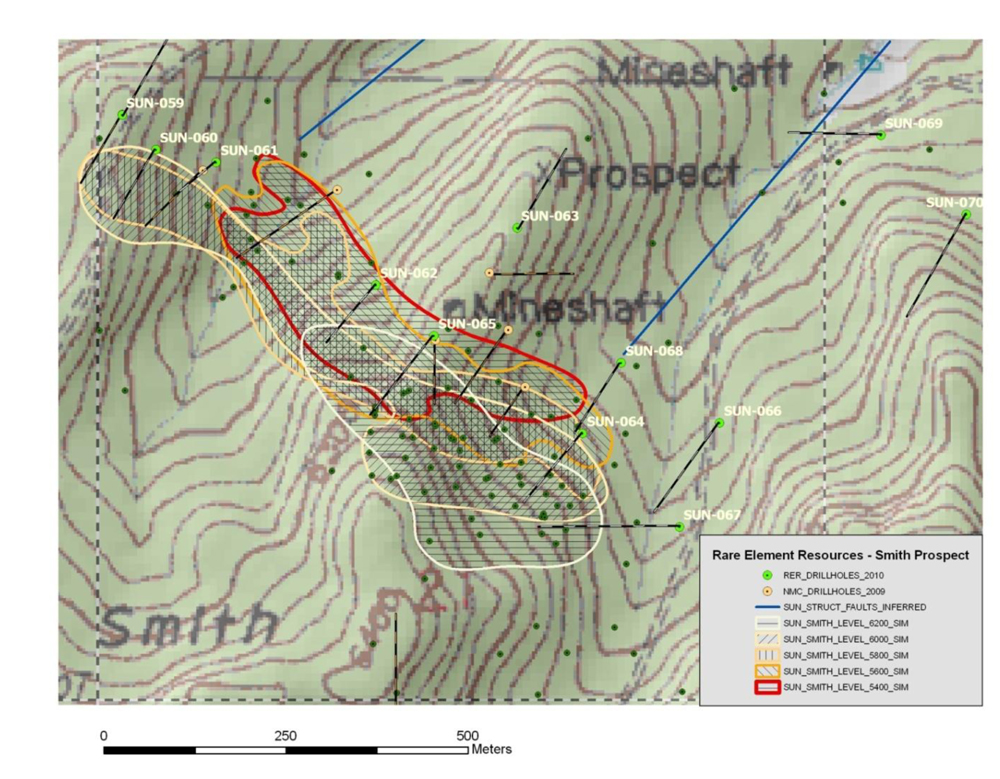
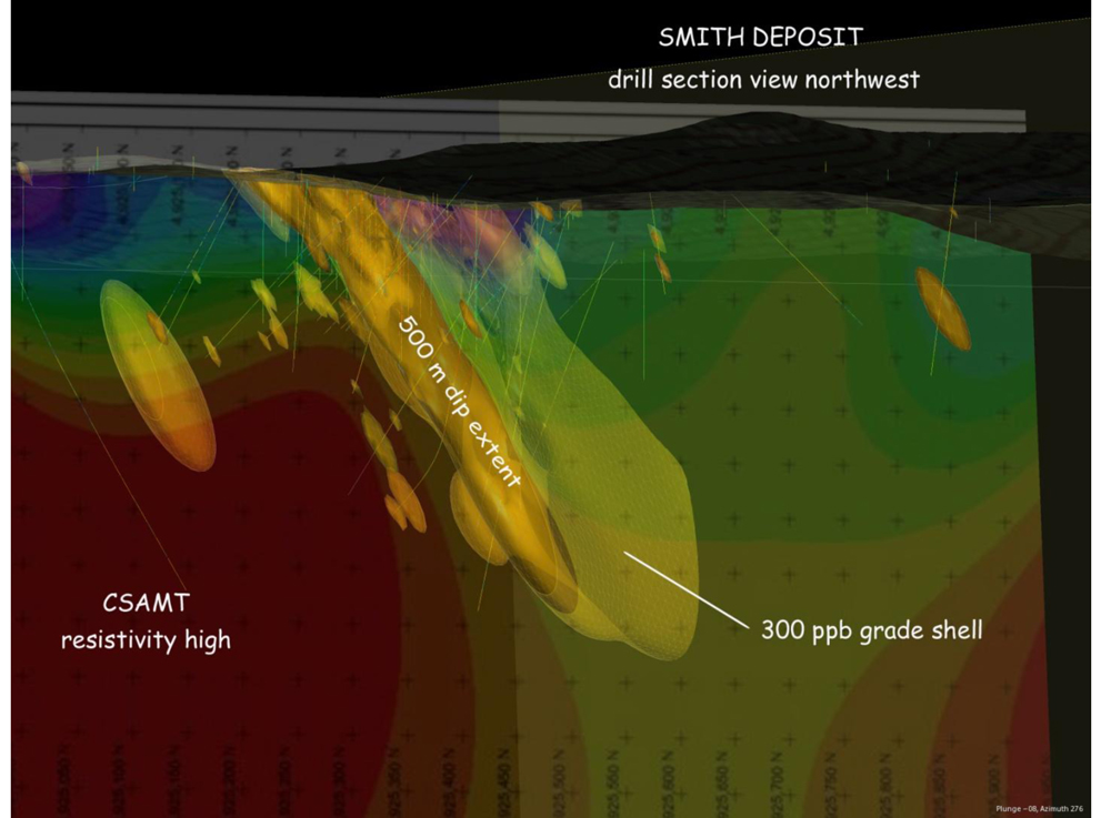
Figure 2 illustrates the general shape of the gold-mineralized zone through a succession of level plans that outline the mineralization at successive depths. Note that mineralization in the near-surface level plan (6200 feet elevation) occurs furthest to the southwest, and each succeeding deeper level plan is located further to the northeast. Figure 2 indicates that the gold-mineralized zone has an overall northwesterly strike and a steep dip to the northeast. A sectional view of the deposit is shown in the LeapFrog image in Figure 3. The deposit shape is coincident with a resistivity boundary shown in the CSAMT image. This remote sensing technique is a tremendous aid in guiding our continued exploration on the Sundance property.
Figure 3: Section of the Smith deposit area showing drill hole traces and interpolated 300 ppb gold grade shell on a base of CSAMT resistivity illustrated by a LeapFrog image. The Smith gold deposit is currently traced along strike for a distance of 1000m and 500m down dip. Note the coincidence of the mineralized body and the sharp resistivity boundary, which is used as a guide for targeting. Higher gold grades of up to 4 ppm are seen at the lower reaches along this contact.
The drilling at the Smith target shows good continuity of the known gold mineralization and provides sufficient drill hole density for the inferred resource estimate. The discovery of good mineralization in the gap between the two historic gold mineralized areas in the East and West Breccias helps to demonstrate and extend that continuity.
Carbon Gold Target
Highlights of the drilling program at Carbon include the following gold assay results:
-
SUN-071 of 0.52 g/t Au over 68.3m (includes 0.96 g/t over 12.2m)
-
SUN-072 of 0.59 g/t Au over 79.3m
-
SUN-077 of 0.41 g/t Au over 51.8m
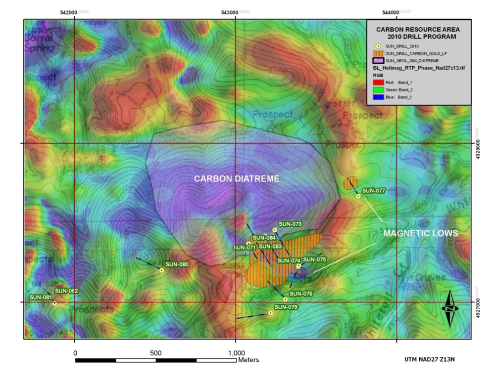
Eight drill holes were completed along the main trend of the Carbon gold zone. Previous exploration drilling focused on crackle breccia, which occurs at the margin of the Carbon diatreme (Figure 3). However, drilling in 2010 discovered new areas of gold mineralization within the diatreme, including intercepts in SUN-071 of 0.52 g/t Au over 68.3m (includes 0.96 g/t over 12.2m) and in SUN-072 of 0.59 g/t Au over 79.3m. It is now apparent that the Carbon diatreme itself is a source of gold mineralization, rather than gold merely hosted by prepared ground at the diatreme margin. Additional drilling on the east side of the diatreme (SUN-077) was designed to test an area of magnetite-destructive alteration and soil gold anomalies, similar to the pattern seen in the Carbon resource area. SUN-077 represents a new gold target area 500m to the east-northeast, with an initial intercept of 0.41 g Au/t over 51.8m (Figure 4). This relationship suggests potential for additional gold resources within and along the margin of the Carbon diatreme, The diatreme margin can be tracked with airborne magnetics and coincident trace element soil anomalies.
Figure 4: Plan map of Sundance Property -- Carbon gold resource area showing location of 2010 drill holes (green collars) and footprint of gold mineralization containing drill intercepts greater than 300 ppb gold. (Drill hole SUN-077 is off the map to the east-northeast.)
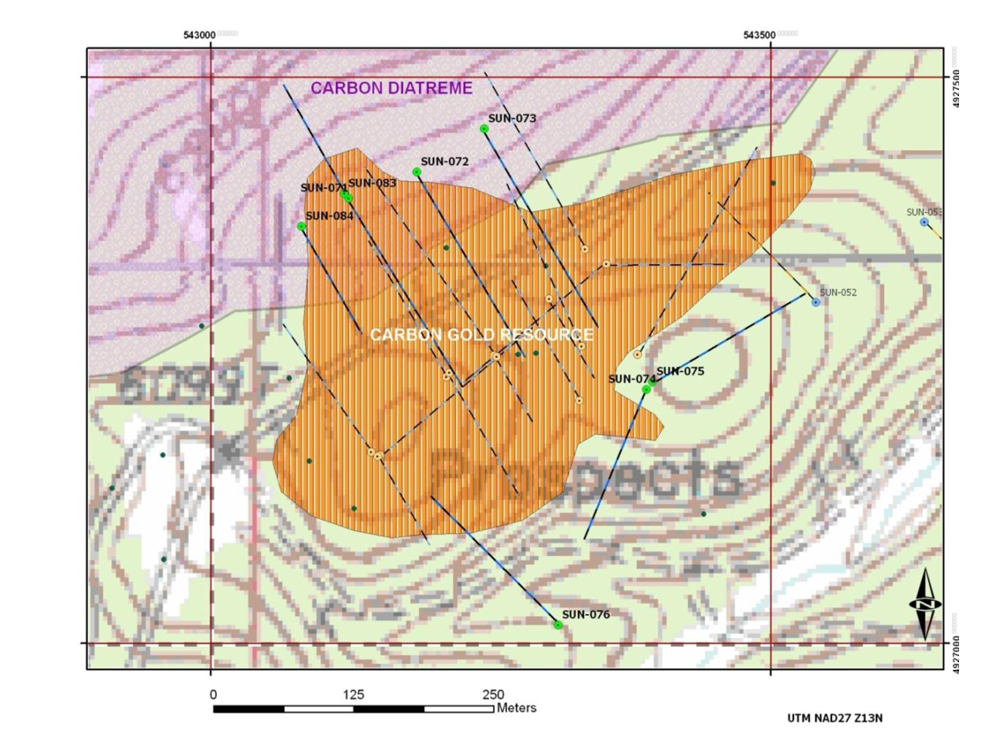
Figure 5: Plan map of part of Sundance Property -- Greater Carbon gold resource area showing location of peripheral 2010 drill holes (yellow collars) and drill inferred gold-mineralized areas (> 300ppb gold) on a base map of airborne magnetics (RTP Phase). Initial drill hole into new mineralization discovered in SUN-077 occurs in an area of low magnetism, similar to the main Carbon resource area on the south side.
Taylor Gold Target
Highlights of the drilling program at Taylor include the following gold assay results:
-
SUN-085 - 0.56 g/t over 71.6m.
-
SUN-089 - 0.67 g/t over 137.2m (includes 3.05 g/t over 12.2m)
-
SUN-090 - 0.67 g/t Au over 192.1m (includes 1.34 g/t Au over 62.5m from the surface)
-
SUN-091 - 0.45 g/t over 56.4m
-
SUN-092 - 0.42 g/t over 64.0m
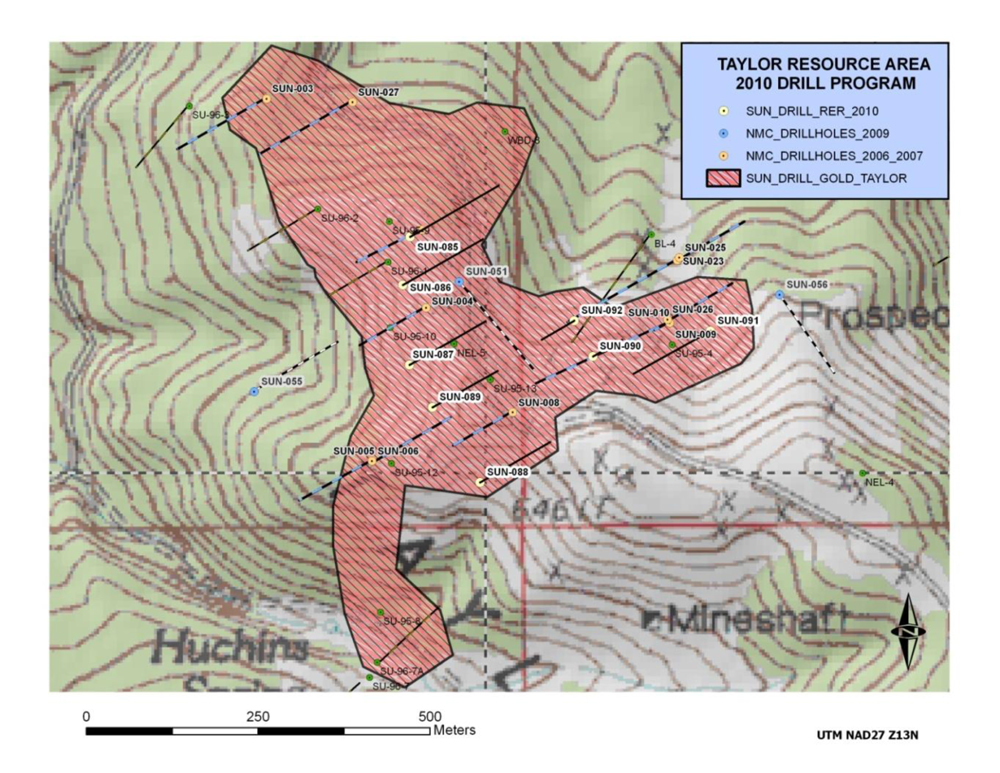
Drilling conducted to define an inferred resource at the Taylor gold target area in 2010 included a total of eight drill holes (SUN-085 through SUN-092). The program was terminated prematurely owing to inclement weather. The Taylor drill hole distribution is shown in Figure 6, along with a polygon depicting the known extent of drill-inferred gold intercepts greater than 300 ppb (>0.3 g/t) Au over significant widths. The gold mineralization at Taylor is a hovering plume-like mass hosted by Tertiary alkaline intrusions and lesser Cambro-Ordovician sandstones of the Deadwood formation. The mineralization generally extends from the surface to depths of about 400 feet (125m). Representative grades within the plume, based on results from the 2010 program, are shown in Table 1 and include 0.56 g/t over 71.6m (SUN-085), 0.67 g/t over 137.2m (SUN-089), 0.45 g/t over 56.4m (SUN-091), and 0.42 g/t over 64.0m (SUN-092). In addition, SUN-089 contains a high grade interval of 3.05 g/t over 12.2m between 515-555 feet (157-169.2m), which may indicate proximity to a feeder structure. Drill hole SUN-090 tested another potential feeder structure, marked by a pronounced resistivity high (2010 CSAMT survey) that extends from depth to intersect the gold-mineralized plume. Gold assay results from SUN-090 contain 0.67 g/t Au over 192.1m, including a high-grade portion with 1.34 g/t Au that extends from the surface to a depth of 62.5m.
Figure 6: Plan map of the Taylor gold resource area showing the location of 2010 drill holes (white collars) with respect to previous drilling, and the footprint of gold mineralization defined by drill intercepts greater than 300 ppb (>0.3 g/t) gold over significant widths.
Higher-grade gold zones seen in drill holes SUN-089 and SUN-090 attest that higher-grade gold zones are present in the Taylor system, and the interpreted continuity of these zones will be used as vectors to further define their extent with additional drilling. An untested CSAMT resistivity anomaly west of the known gold mineralization at Taylor could represent the roots of a second satellite shoot of the gold mineralization. Another key result from this year's program is the interpretation of the 'hovering' aspect of plume-like portions of both the Taylor and Carbon gold systems, where deeper intersections in drill holes can be in barren rock underlying anomalous gold at shallower depths within the plume.
Geophysical Survey -- CSAMT
A CSAMT (Controlled Source Audio-Magnetotelluric Technique) survey along four lines totaling 8.6 line kilometers was designed by Condor Consultants and completed by Zonge Engineering in August to cover the Taylor gold and Bull Hill REE targets. This type of survey was successful in defining a relative conductive structure in the Smith gold zone that harbors the bulk of the known gold mineralization there. The results of this year's survey will be utilized for further definition drilling of the Taylor gold resource and the search for high-grade feeder zones, as well as guiding further exploration of carbonatite-hosted REE mineralization at Bull Hill.
Mineral Resources are not Reserves
Mineral resources that are not mineral reserves do not have demonstrated economic viability. Mineral resource estimates do not account for minability, selectivity, mining loss and dilution. These mineral resource estimates are in the inferred mineral resource category. Inferred mineral resources are normally considered too speculative geologically for the application of economic considerations that would enable them to be categorized as mineral reserves, however they are allowed to be included in a preliminary economic assessment. There is also no certainty that these inferred mineral resources will be converted to measured and indicated mineral resource categories through further drilling, or into mineral reserves once economic considerations are applied.
Quality Assurance
The mineral resource estimate was completed by Mr. Alan C. Noble, P.E., principal engineer of Ore Reserves Engineering, and is based on geological interpretations supplied by the Company to ORE and subsequently modified by ORE. Mr. Noble is an independent qualified person for the purposes of National Instrument 43-101 standards of disclosure for mineral projects of the Canadian Securities Administrators and has verified the data disclosed in this release.
The Rare Element Resources' field programs were carried out under the supervision of Dr. James G. Clark, LGeo, the Company's Vice President of Exploration and a qualified person for the purposes of National Instrument 43-101 standards of disclosure for mineral projects of the Canadian Securities Administrators. Dr. Clark has direct experience with the project dating back to 1986. Mr. John Ray, who has experience with the gold project continuously from 2004 through 2010, managed the geological, drilling, and sampling program on the Sundance gold project during this period of time.
A detailed QA/QC program was implemented by the Company for the 2010 drill program. The 2009 QA/QC program was organized by Dr. Jeffrey Jaacks. Dr. Jaacks, Dr. Clark, and Mr. Ray have verified the 2010 sampling procedures and QA/QC data delivered to ORE. They share the opinion that the data are of good quality and suitable for use in the resource estimate.
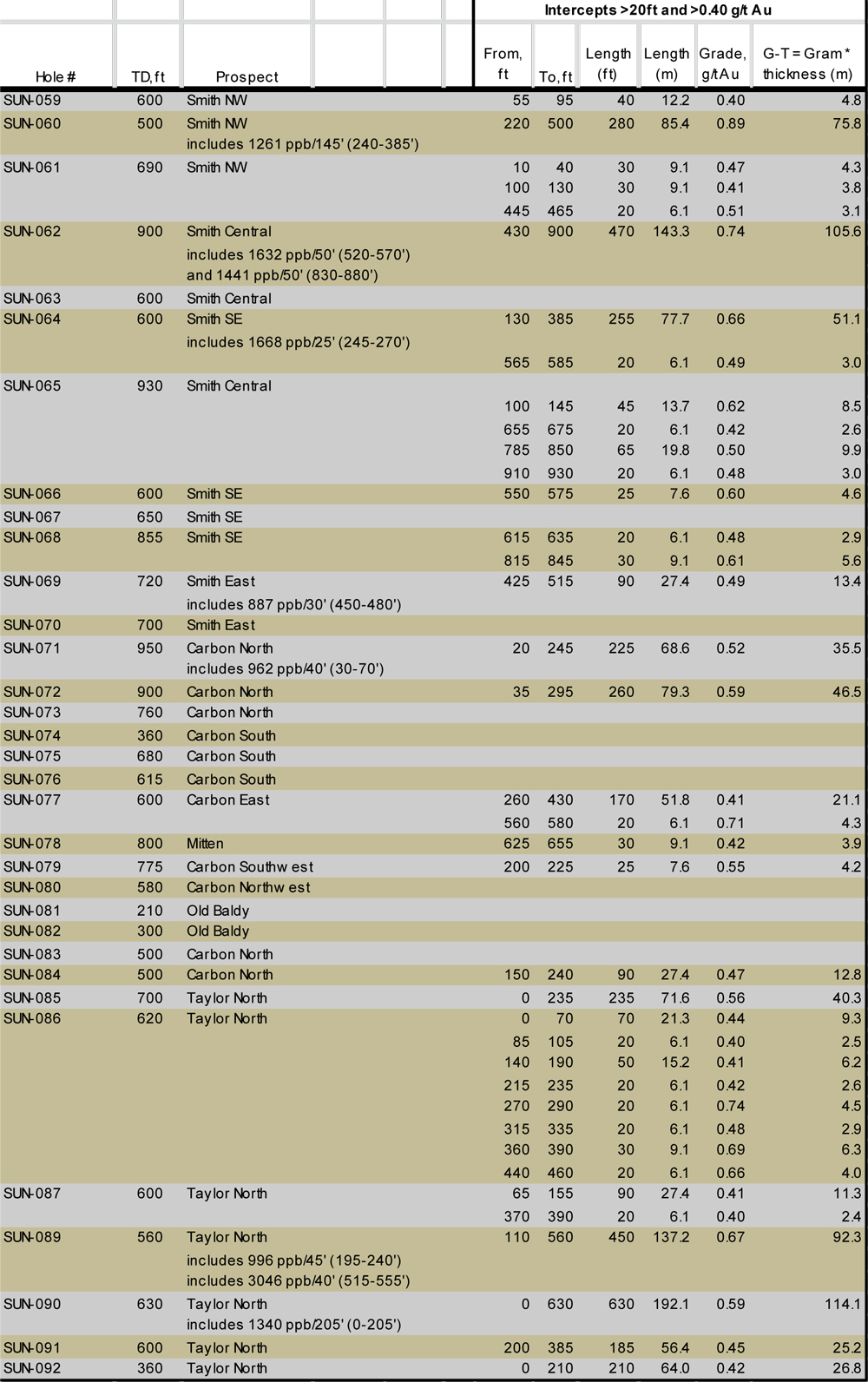
Table 2: Summary of significant gold mineralization in 2010 drill holes
Rare Element Resources Ltd (TSX-V:RES) is a publicly traded mineral resource company focused on exploration and development of rare-earth elements and gold on the Bear Lodge property. Gold exploration is being conducted as the Sundance project.
Rare-earth elements are key components of the green energy technologies and other high-technology applications. Some of the major applications include hybrid automobiles, plug-in electric automobiles, advanced wind turbines, computer hard drives, compact fluorescent light bulbs, metal alloys, additives in ceramics and glass, petroleum cracking catalysts, and a number of critical military applications. China currently produces more than 95% of the 130,000 metric tonnes of rare-earths consumed annually worldwide, and China has been reducing its exports of rare earths each year. The rare-earth market is growing rapidly, and is projected to accelerate if the green technologies are implemented on a broad scale.
ON BEHALF OF THE BOARD
Donald E. Ranta, PhD, PGeo, President & CEO
For information, refer to the Company's website at www.rareelementresources.com or contact:
Mark T Brown, CFO, (604) 681-4236 mtbrown@pacificopportunity.com .
Donald E Ranta, (604) 681-4236 don@rareelementresources.com
Donald E. Ranta, PhD, PGeo, serves the Board of Directors of the Company as an internal, technically Qualified Person. Technical information in this news release has been reviewed by Dr. Ranta and has been prepared in accordance with Canadian regulatory requirements that are set out in National Instrument 43-101. This news release was prepared by Company management, which takes full responsibility for content. Neither TSX Venture Exchange nor its Regulation Services Provider (as that term is defined in the policies of the TSX Venture Exchange) accepts responsibility for the adequacy or accuracy of this release.